Driving the Future of Surveying: 12d Synergy and Leica Geosystems Partner for Seamless Data Workflows

In a major step forward for surveyors and geospatial professionals, 12d Synergy has officially partnered with Leica Geosystems as a Technology Partner, bringing powerful integration capabilities directly into Leica Geosystems’ software ecosystem. The integration, now live with Leica Infinity and GeoCloud Drive, introduces a native connector to 12d Synergy, allowing professionals to seamlessly manage their data workflows from field to office.
An Integration That Closes the Gaps
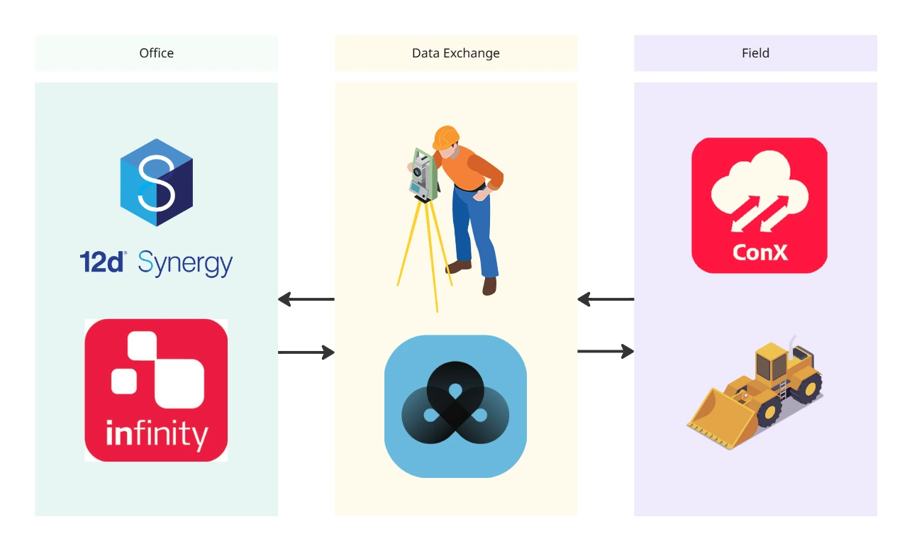
Unlike traditional data transfers, this is a fully integrated solution that connects systems at a deeper level. This connector enables users to directly link Leica Infinity, Leica ConX, and HxGN GeoCloud with 12d Synergy’s CDE. Through Leica ConX and HxGN GeoCloud, teams can also streamline data flows to field tools like Leica Captivate and Leica iCON. That means no more manual file transfers, no more USB drives, no more emailing data, and critically, no duplicate data.
Traditionally, there has been a clear divide between the field and office, as well as design to field workflows. Surveyors often move files manually – copying data onto USBs – only to find that the version they’re working with is outdated or unmanaged. Without an automated, end-to-end workflow, the risk of data errors and inefficiencies increases.
12d Synergy now connects to the ecosystem of Leica Geosystems which encompasses field (e.g. Leica Captivate, Leica iCON), office (Leica Infinity) and Cloud Services (HxGN GeoCloud Drive and Leica ConX). With 12d Synergy’s integration with Leica Geosystems, survey data flows bi-directionally, empowering field teams to work with the latest design files and allowing their captured data to return directly into the design process. Surveyors become active contributors to the WIP (Work in Progress) phase, breaking down traditional silos and building a truly connected ecosystem.
Rich Features, Real Efficiency
The Leica Geosystems – 12d Synergy integration is more than just file syncing— it’s about transforming how data is authored, shared, and maintained.
While traditional CDEs typically manage only singular files, 12d Synergy is data agnostic and has the ability to manage survey authoring tools as a structured file database, enabling efficient control of surveyors’ WIP projects. Whether your team is using 12d Model, BricsCAD, or other tools, Synergy can manage that data in context. That’s a massive leap forward in quality control, risk reduction, and long-term project traceability.
The integration with Leica Infinity allows surveyors to connect directly to the 12d Synergy server, load projects and data into their software, and similarly send outputs directly back to the platform—all without leaving the authoring environment. This results in significant time savings, reduced rework, and increased confidence that everyone is working from a single source of truth.
Streamlining Survey Workflows
Laser scanning and geospatial data capture are becoming increasingly data intensive.
The future of surveying lies not just in precision, but in data accessibility and continuity. By enabling bi-directional movement from tools like Leica Infinity, Leica Captivate, Leica ConX, and HxGN GeoCloud to 12d Synergy’s CDE, surveyors benefit from:
• Field-to-office continuity with automatic version control
• Reduced duplication and errors due to automated check-ins and check-outs
• Complete audit trails for compliance and transparency
• End-to-end survey workflows
This is a significant improvement over traditional disconnected workflows, which relied heavily on trust and manual processes to keep data in sync.

Built for the Reality of Surveying
Leica Geosystems’ software ecosystem—while powerful—is primarily focused on the prefect surveying ecosystem. 12d Synergy’s integration acts as a unifying layer, connecting different parts of the Leica Geosystems software stack into a cohesive system that respects the specific needs of survey teams. By aligning Leica Geosystems’ world-class hardware and software with 12d Synergy’s data management capabilities, this partnership helps teams do more with less—faster, smarter, and with fewer risks.
Bridging the WIP Gap for Surveyors
One of the most common gaps in today’s Common Data Environments (CDEs) is how they handle Work In Progress (WIP) data for surveyors. Too often, CDEs are chosen with only designers or engineers in mind—leaving survey teams disconnected and reliant on manual processes. 12d Synergy changes that. It’s built to support the entire project team, including surveyors, from start to finish. By enabling real collaboration between surveyors, designers, BIM and other technical teams, it breaks down data silos and ensures no team is left out of the digital workflow.
By implementing 12d Synergy as a WIP CDE, which adheres to these standards, your business can improve its final project delivery, ultimately resulting in increased customer satisfaction and a reputation for your business.
This partnership underscores a shared commitment to the future of surveying—one where total stations and GPS/GNSS, laser scanning, smart data management, and connected environments converge.
With Leica Geosystems and 12d Synergy now working hand-in-hand, surveyors and engineers can enjoy a seamless, efficient, and intelligent workflow that spans from office to field and back again. Additionally, 12d Synergy supports ISO 19650 compliance by providing structured, version-controlled workflows and a complete audit trail, ensuring information is managed consistently throughout the asset lifecycle.
For a more comprehensive overview of the ISO19650 series, and why it’s important for your business, visit our ISO-19650 Guide.
Learn more about CDE for Surveyors in this detailed guide.
Want to know more about our partnership with Leica Geosystems?
Learn how to get the most out of 12d Synergy’s partnership with Leica Geosystems and how to implement it for your business today.
